
CONTENTS
Blacklands
Quest for the Blacklands Boundary
Blacklands Boundary Found!
Blacklands Streets (now inclusive of 1891 additional roads)
Some Further Reading
Blacklands
When I moved into Hughenden Road, near Ore Station, I joined 'Nextdoor' to get in touch with other folk who live in the area. I was automatically added to the 'Blacklands' group. At that time, I had no idea what Blacklands was, except there was a rather prominent building down the other end of the street with 'Blacklands, Erected A.D. 1895' plastered across its front.

Discovering that my basement was once a stable encouraged me to research the history of some local buildings, people and events in the Blacklands area... snippets and tales I was soon bursting to share.
I thought 'Broadsheet'.
Why 'broadsheet'? Probably because the historical books I spent years writing all involved reading Seventeenth Century broadsheets, single news sheets, which I loved because of their simplicity of focusing on one news item or event at a time. So, a Blacklands broadsheet it would be. What a perfect way to share fascinating snippets and tales with folk who are a little bit curious about where they live and about the people who made it what it is today!
Good thinking. So, next I thought... who are Blacklanders and where do I find them?
Obviously, Blacklanders live in Blacklands.
Obviously.
Fine. So, where exactly does Blacklands extend to? Who is in the area and who is out of it? In other words, where is the boundary of the area?
And that's where things became tricky...
Quest for the Blacklands Boundary
You'd think defining an area that's been defined for over a century would be straight forward, wouldn't you? But, no. It wasn't nearly as simple as I thought it would be. First, I searched online, poring over many maps, both historical and new, most emblazoned with 'Blacklands' somewhere near Christ Church on Laton Road, so I guessed that was probably pretty central. However, no map showed me a boundary.

Descriptions on local history sites, such as 1066 Online, revealed Blacklands had been part of Blacklands Farm Estate, and that it had been bordered by Kite's Nest Farm, Hole Farm, St Helen's Wood and Ore Valley Fields, but I couldn't find exactly where all of these places were, nor even where the Blacklands Farm, surrounded by its 45 acres of dairy meadows, was centred. Kite's Nest Farm and St Helen's Wood were fairly easy to find; that was a start. However, the only Blacklands Farm on GenUK was way off in Hollington. Obviously not the one:

I searched so many maps my mind boggled, and found parish borders for Saint Mary in the Castle, Ore, St Andrews and others, but no Blacklands boundary. So frustrating!
Then I thought 'Of course! Hastings Council will have a map!' I was excited to find a map for Blacklands Conservation Area on the Council website, but was quickly disappointed it didn't cover the whole area. Streets I knew should be within the area, like Beaconsfield Road and Hughenden Road weren't included, so there was no knowing what other streets were missing. Again, frustrating!
But, surely, Hastings Council had to have a map, Didn't it? Turns out, they don't. On enquiring, I was directed first to the Conservation Area map I'd already looked at, then, when I pointed out it was incomplete, it was suggested I try the Museum.
I didn't get that far. First, I went and bothered the librarians in the town library. I have to say, I thought I would find several books on Blacklands. There were none at all on the Local Reference shelves. Luckily, the helpful staff took an excursion down into the basement 'store' and found me two very thin books, a folder and a couple of loose photos. That was all they had in the Library. There had once been a third booklet, but someone had walked away with it.
The almost miniature blue hardback was solely about Christ Church, Blacklands, but the thin white booklet in that little bundle was exactly what I was looking for: a whole page describing the parish boundary - yay!
Blacklands Boundary Found!
And, here it is, my reconstruction. I read and re-read the relevant page until I was able to reconstruct the border. This is what I came up with:
Yes!!
It might have taken a couple of weeks, but it was worth it - I had it! My answer.
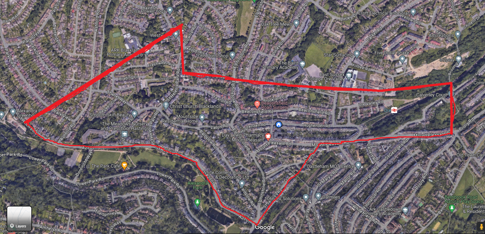
And, today, to celebrate the grand achievement of finally knowing what streets are included in the border — and so, where I can find the Blacklanders — I walked every one of them (This is my 3 hour Map My Walk map of just over 9 miles!):
.jpeg)

So, if you live here in Blacklands, or have ever lived in this area, you are a Blacklander! I hope you like a little bit of history, because I have some lovely little snippets and tales to share with you :-)
[[Edit: I have now located a copy of the account of the parish — the small book missing from the library — from Reverend James Morgan (vicar of Christ Church, Blacklands from 1927) who describes an added triangle of land newly included in the parish in 1891, which I don't believe was included in the description I drew the boundary here upon. Update to follow to include new streets: "In 1891 the Parish boundaries were extended by the inclusion, by an Order in Council of February 23rd of that year, of a triangular portion reaching from Elphinstone Road to the upper part of St. Helen's Park Road, and enclosing the lower portion of Downs Road and the old Kite's Nest Hotel, the footpath from Elphinstone Road to St. Helen't Park Road forming the new boundary." ]]
Today - 16th April '24 - I walked the additional area to find out what other streets should be added:
.png)
So, the total street area now looks like this:

Blacklands Streets (now inclusive of 1891 additional roads):
- Ashford Road (between St Helen's Rd and Tenterden Rise)
- Baldslow Road
- Beaconsfield Road
- Blacklands Drive
- Brading Close
- Brookland Close
- Broomsgrove Road (from Mount Pleasant Road to Broomsgrove Bridge)
- Cromer Walk
- Down's Road (1-25, 12-48)
- Elphinstone (to Blacklands Drive)
- Elphinstone Avenue (only East-West section to school)
- Fearon Road
- Freshwater Avenue
- Hole Farm Close
- Hughenden Place
- Hughenden Road
- Keppel Road
- Laton Road
- Manston Way
- Mount Pleasant Crescent
- Mount Pleasant Road
- Ore Valley Road
- Osborne Close
- Parker Road (from Hughendend Road to Baird Primary School entrance)
- Park View (A few houses at Ashford Road end)
- Pegwell Close
- Quarry Crescent
- Quarry Road
- Quarry Terrace
- Sedgebrook Gardens
- Sherwood Close
- St Helen's Court
- St Helen's Crescent
- St Helen's Park Road
- St Helen's Road (from Park Gates Roundabout to just beyond Ashford Road)
- St James's Road
- Thanet Way
- Turing Way
- Woodbrook Road
Some Further Reading:
Christ Church, Blacklands (The Centenary History of a Late Victorian Church); Ralph, Richard; Hastings 1981
History of the Church and Parish of Christ Chrch, Blacklands, Hastings 1878-1928; Morgan, Rev. James, D.D.; Budd A. Gillatt, St Leonards on Sea 1928
Blacklands History; 1066Online
Blacklands; Historical Hastings
Blacklands Conservation Site 3; Hastings Borough County Council


Great first post! Obviously, a lot of time and research has gone into this post. Obviously. Your efforts have linked together fractured information and presented them in an easily digestible way. I'm looking forward to your next post.
ReplyDeleteEnjoyable read, looking forward to hearing stories about the area!
ReplyDeleteThank you Dog-Hearted Dreamer and Jazzwick Jr! I really appreciate your taking time to discover more about Blacklands. I hope you come back and enjoy more interesting snippets from the area :-) I'll look forward to seeing you!
ReplyDeleteHello, Annelisa,
ReplyDeleteI really enjoyed reading your broadsheet with its excellent research - thank you.
I love local history and have an old map showing the very first terrace of houses in Parker Road at the end of the 19th century - this was built before several of the houses in Beaconsfield Road. I have even tracked the occupants through the censuses from 1901. So please add nos. 1-15 Parker Road to the list of streets in Blacklands. Thanks!
And I look forward to reading more of your discoveries in the future.
Thank you so much for your comment, Thameslass. Thank goodness you stopped by! I hadn't realised I had forgotten to include those houses of Parker Road and will rectify this now. It is through the knowledge of others such as yourself that hopefully I can become more accurate and produce a better account.
DeleteI too have looked at some of the census around the turne of the last century... fascinating... and so great to really get a better feel for how it might have been to live around here back then!
I have also, since doing the original research, found online a booklet that was missing from the library and outlines an additional triangle of land in 1891, which I walked yesterday, so will be adding the roads to the list. Here's hoping I'm not leaving out anybody else!
Thanks, Annelise.
DeletePlease don't worry about forgetting about our 8 houses - we often get 'forgotten' as we're in out on a limb. Having our electoral ward changed frequently means even prospective councillors are often unsure which ward we're in (we're now in Braybrooke instead of Baird), so we either get info from at least two candidates from each party, or from none at all!
I'm now very intrigued by that additional triangle in Blacklands 🙂
P S. May I suggest that in the next broadsheet you put the URL of this website (rather than that QR code which annoyingly leads the unwary to a subscription site)? Your first broadsheet inspired me to check out the local history info (as well as the family history of this house) that I've collected over the many years we've lived here, so I do hope there'll be a second!
That's funny about getting double or nothing of all the eloctoral info! I expect that must be particularly frustrating if you actually want to find out about which of the candidates are running...
DeleteI've now updated the list and post to include the additional triangle, also learning about the footpath that runs from Elphinstone Road up to near where the old Kite's Nest Farm, (and then Kite's Nest Hotel) used to be at the top of St Helen's Park Road. Two Roads were added to the list (although, from a comment below, it looks like that area is increasing again! :-D )
Re the broadsheet, I'm going to try not to only do place-history, but people as well. I'm currently researching someone born in our local who's fame spread worldwide... coming soon...
(Oh, and I'll take your advice about putting up the URL. I've never been taken to a subscription site, nor did my family, so I'm puzzled about that. I'll get some more folks to test it. Thanks for letting me know :-) )
DeleteHi Annalisa, thanks for your Blacklands & Beyond broadsheet No. 1, which is very interesting; you have put a lot of effort into finding and sharing the history of Blacklands. My house, built in 1972, is in Ashford Road, between Park View and Thanet Way. My late father-in-law, as well as a good friend of my wife, both spoke of remembering a field of cattle and a pond, somwhere around the end of Pegwell Close, I'm assuming some time in the 1960's. While landscaping my back garden I routinely uncover the remains of foundations and old bricks, probably a cowshed, I imagine.
ReplyDeleteMany thanks,
Nick
Hi Nick, and thank you for stopping by!
DeleteThat's really interesting. Many local people I've spoken to seem to remember different things of the area, everything from chicken running free, fields of corn, pigs etc. I know from 1851 to 1861 the Blacklands Farm was occupied by a dairy farmer / milkman, so I presume you are right and there was a cowshed somewhere around... maybe the bricks in your garden mark the very spot!
This is great! I look forward to hearing more about the history of Blacklands!
ReplyDeleteThank you, Alison. It's always nice to know others who are interested in a little bit of history, especially around where we live. I hope to have a new one out (time permitting) about every month. There's so much to research and find out about. It's going to be fun :-D
DeleteIan Shiner from the Historical Hastings facebook group found this info which may be of interest...
ReplyDeleteHastings and St Leonards Observer - Saturday 19 February 1938
STEPS are being taken to make some slight revision of parish boundaries in the Hastings Rural Deanery. It is expected that this will comprise a slight addition to Christ Church, Blacklands, of two portions which, by a private arrangement with the incumbents, are at present supervised by the Vicar of Blacklands (the Rev. Dr. James Morgan).
These districts comprise the lower end of Parker-road to No. 65, Elphinstone-avenue, and the houses in Elphinstone-road on the frontage of the avenue with a few additional houses in Downs-road as far "Abbotsford." These, at present, are in Ore parish. It is also proposed to add a portion from the parish of St. John's, Holllngton, namely, the upper portions of Parkview and Park-drive. Half of the Parkview estate is already included in Blacklands, and the new boundary would include the whole of the estate and the houses in St. Helen's-road up to No. 155.
The written permission of the various incumbents and also that of the patrons of the several livings has been given, and the proposal is recommended by the diocesan authorities, and if it meets with the approval the Ecclesiastical Commissioners an " Order in Council" will be made sanctioning the alteration.
Oh my goodness! So, even the additional bit I found added wasn't the whole of it? That's an amazing find, Alison! Well done. I wonder if that proposal was carried out... the area could be a fair few houses bigger than I already have. Somewhere there must be a complete plan. I'm now thinking the Church itself might have the answer. I'll try getting in touch and see if they know what it currently is. Thanks for this great info! :-)
DeleteHi,
ReplyDeleteLove the blog and broadsheet.
While today "Blacklands" exists as an Estate Agent's term and as part of the parish of Christ Church Blacklands and St Andrews, is was originally a farm estate. For some reason, that I have not discovered, the Blacklands estate came into the ownership of John Collier (1685-1760). Kent Baker has writen a biography of Collier entitled "Mister Hastings".
When Collier died he had no sons and his estate was divided between his daughters. Sarah Sayer (nee Collier) inherited the Blacklands estate and it passed down the Sayer family.
In 1845 Maria Lane Sayer inherited Balcklands. In 1861 she sold the entire Blacklands estate (less a plot that had been sold to the Railway Company) to the one time MP and anti-catholic campaigner, Charles Hay Frewen (1813-1878). Frewen built the Blacklands Church and sold off the estate for housing development. The 1861 conveyance between Lane Sayer and Frewen is available to see at the County Archive Office (The Keep Falmer). The coveyance includes a plan showing exactly the boundaries of the Blackland estate. I suggest that this plan shows the true boundaries of Blacklands.
My house is build on land bought from Frewen in a deal dated 1875 and, as part of researching my house's history, I went and saw the 1861 conveyance.
Thank you, Graham
ReplyDeleteActually, I have all of this information as an as-yet-unpublished post, which I was saving for the third issue (I don't want to do 'Places' every time, but want to alternate with posts about people of Blacklands). That was my starting point.
But when the Blacklands Farm Estate became part of the Blacklands Parish, I felt that developement was an important one that grew the area slightly, right up to Hole Farm and Kite's Nest Farm. Other alterations (which I found in the second pamphlet mentioned in the blog above), made sense, especially when I walked it. Another commenter, Alison, above talks of some proposed 1938 changes.
Therefore, although the original Blacklands area did include the Blacklands Farm Estate, the original parish was slightly larger, and the second change was slightly larger again. The 1938 proposal may actually have come into affect. And seeing as it is still based on the parish area which the Christ Church is 'responsible for', my feeling is that it should include whatever additional areas are considered part of it. Like all historical things, they are ever-changing. Perhaps the best we can do is record the changes...
Thank you so much for visiting and commenting. I love the input and would love to see your thoughts on future posts as they're published. I am sure I will be corrected often, and that's okay. Maybe between us all we can get a better picture of our home area :-)
By the way, I have all the articles, letters and estate plans marked ready to check out when I get a chance to go to the Keep. I'm really excited about going!!
Hi Annelisa, I’ve just discovered your blog through the QR code on the Blacklands and Beyond broadsheet that was delivered to my address in in Cromer Walk, but I couldn’t find it listed on the streets included in the boundaries of Blacklands. There are only 7 houses where I live off road between Mount Pleasant Rd and Quarry Rd. They were built in the 1980s. I assume because I received the Broadsheet that we are part of Blacklands. I really enjoyed reading about Mary Ann Slade and her daughter Jane Elizabeth Strickland. I’ve lived here for nearly seven years and felt the area lacked a certain identity (unlike the West Hill where I previously lived). But reading your blog makes me proud to be a Blacklander! It would be great to have an event to bring us together to celebrate this interesting area and get to know more of our neighbours. Maybe later in the year at Blacklands church hall? I’d be interested in helping to organise it 🙂😙
ReplyDeleteHi and thanks for both stopping by here and for commenting - it's lovely to hear from other people from the area!
DeleteI've just checked, and you were right - I had Cromer Walk in the sidebar but not in the above post. Although I'm going to be updating the Blacklands boundary soon, since the lovely Reverend Murrills sent me the latest version last year, but, sadly, stuff happened and I forgot all about it. Reading some of the comments on this post reminded me to look back in my email account. Of course, the houses down your walk are still very much in the area, since the railway line was the original boundary and remains so (updated map coming soon).
Indeed, we were very lucky to have our very industrious local author, Helena Wojtczak, to contribute the post about Mary Ann Slade and Jane Elizabeth Strickland... She is currently writing about another of our local historical Blacklands residents, so I'm hoping she might give us a little preview when her next book is due to come out! I'm looking forward to it.
Funny you should say that about being proud to be a Blacklander - the other day, I drove back from Eastbourne, and when I reached St Helen's Road where Blacklands starts from that direction, I had a very definate warm feeling and an inner smile... it really felt like coming home! I hope that others in the area might find a little of that feeling too, while finding out about how our area came about, and all the folk who lived here!
Interesting idea about the event... I know there are various events around and about for various things, but I'd be interested in talking about this with you! Are you on Nextdoor at all?