
When I moved into Hughenden Road, near Ore Station, I joined 'Nextdoor' to get in touch with other folk who live in the area. I was automatically added to the 'Blacklands' group. At that time, I had no idea what Blacklands was, except there was a rather prominent building down the other end of the street with 'Blacklands, Erected A.D. 1895' plastered across its front.

Discovering that my basement was once a stable encouraged me to research the history of some local buildings, people and events in the Blacklands area... snippets and tales I was soon bursting to share.
I thought 'Broadsheet'.
Why 'broadsheet'? Probably because the historical books I spent years writing all involved reading Seventeenth Century broadsheets, single news sheets, which I loved because of their simplicity of focusing on one news item or event at a time. So, a Blacklands broadsheet it would be. What a perfect way to share fascinating snippets and tales with folk who are a little bit curious about where they live and about the people who made it what it is today!
Good thinking. So, next I thought... who are Blacklanders and where do I find them?
Obviously, Blacklanders live in Blacklands.
Obviously.
Fine. So, where exactly does Blacklands extend to? Who is in the area and who is out of it? In other words, where is the boundary of the area?
And that's where things became tricky...
Quest for the Blacklands Boundary
You'd think defining an area that's been defined for over a century would be straight forward, wouldn't you? But, no. It wasn't nearly as simple as I thought it would be. First, I searched online, poring over many maps, both historical and new, most emblazoned with 'Blacklands' somewhere near Christ Church on Laton Road, so I guessed that was probably pretty central. However, no map showed me a boundary.

Descriptions on local history sites, such as 1066 Online, revealed Blacklands had been part of Blacklands Farm Estate, and that it had been bordered by Kite's Nest Farm, Hole Farm, St Helen's Wood and Ore Valley Fields, but I couldn't find exactly where all of these places were, nor even where the Blacklands Farm, surrounded by its 45 acres of dairy meadows, was centred. Kite's Nest Farm and St Helen's Wood were fairly easy to find; that was a start. However, the only Blacklands Farm on GenUK was way off in Hollington. Obviously not the one:

I searched so many maps my mind boggled, and found parish borders for Saint Mary in the Castle, Ore, St Andrews and others, but no Blacklands boundary. So frustrating!
Then I thought 'Of course! Hastings Council will have a map!' I was excited to find a map for Blacklands Conservation Area on the Council website, but was quickly disappointed it didn't cover the whole area. Streets I knew should be within the area, like Beaconsfield Road and Hughenden Road weren't included, so there was no knowing what other streets were missing. Again, frustrating!
But, surely, Hastings Council had to have a map, Didn't it? Turns out, they don't. On enquiring, I was directed first to the Conservation Area map I'd already looked at, then, when I pointed out it was incomplete, it was suggested I try the Museum.
I didn't get that far. First, I went and bothered the librarians in the town library. I have to say, I thought I would find several books on Blacklands. There were none at all on the Local Reference shelves. Luckily, the helpful staff took an excursion down into the basement 'store' and found me two very thin books, a folder and a couple of loose photos. That was all they had in the Library. There had once been a third booklet, but someone had walked away with it.
The almost miniature blue hardback was solely about Christ Church, Blacklands, but the thin white booklet in that little bundle was exactly what I was looking for: a whole page describing the parish boundary - yay!
Blacklands Boundary Found!
And, here it is, my reconstruction. I read and re-read the relevant page until I was able to reconstruct the border. This is what I came up with:
Yes!!
It might have taken a couple of weeks, but it was worth it - I had it! My answer.
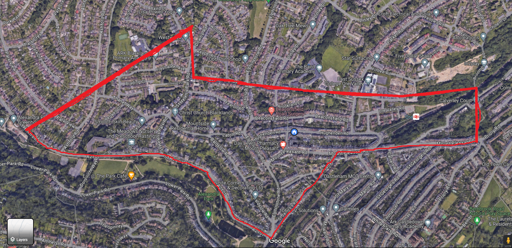
And, today, to celebrate the grand achievement of finally knowing what streets are included in the border — and so, where I can find the Blacklanders — I walked every one of them (This is my 3 hour Map My Walk map of just over 9 miles!):
.jpeg)

So, if you live here in Blacklands, or have ever lived in this area, you are a Blacklander! I hope you like a little bit of history, because I have some lovely little snippets and tales to share with you :-)
[[Edit: I have now located a copy of the account of the parish — the small book missing from the library — from Reverend James Morgan (vicar of Christ Church, Blacklands from 1927) who describes an added triangle of land newly included in the parish in 1891, which I don't believe was included in the description I drew the boundary here upon. Update to follow to include new streets: "In 1891 the Parish boundaries were extended by the inclusion, by an Order in Council of February 23rd of that year, of a triangular portion reaching from Elphinstone Road to the upper part of St. Helen's Park Road, and enclosing the lower portion of Downs Road and the old Kite's Nest Hotel, the footpath from Elphinstone Road to St. Helen't Park Road forming the new boundary." ]]
Today - 16th April '24 - I walked the additional area to find out what other streets should be added:
.png)
So, the total street area now looks like this:

Blacklands Streets (now inclusive of 1891 additional roads):
- Ashford Road (between St Helen's Rd and Tenterden Rise)
- Baldslow Road
- Beaconsfield Road
- Blacklands Drive
- Brading Close
- Brookland Close
- Broomsgrove Road (from Mount Pleasant Road to Broomsgrove Bridge)
- Down's Road (1-25, 12-48)
- Elphinstone (to Blacklands Drive)
- Elphinstone Avenue (only East-West section to school)
- Fearon Road
- Freshwater Avenue
- Hole Farm Close
- Hughenden Road
- Keppel Road
- Laton Road
- Mansion Way
- Mount Pleasant Crescent
- Mount Pleasant Road
- Ore Valley Road
- Osborne Close
- Parker Road (from Hughendend Road to Baird Primary School entrance)
- Park View (A few houses at Ashford Road end)
- Pegwell Close
- Quarry Crescent
- Quarry Road
- Sedgebrook Gardens
- St Helen's Court
- St Helen's Crescent
- St Helen's Park Road
- St Helen's Road (from Park Gates Roundabout to just beyond Ashford Road)
- St James's Road
- Thanet Way
- Turing Way
- Woodbrook Road
Some Further Reading:
Christ Church, Blacklands (The Centenary History of a Late Victorian Church); Ralph, Richard; Hastings 1981
History of the Church and Parish of Christ Chrch, Blacklands, Hastings 1878-1928; Morgan, Rev. James, D.D.; Budd A. Gillatt, St Leonards on Sea 1928
Blacklands History; 1066Online
Blacklands; Historical Hastings
Blacklands Conservation Site 3; Hastings Borough County Council

